Washington Avenue Corridor Study (WACS)
Let's create a better Washington Avenue for all! The Houston-Galveston Area Council (H-GAC) has established a partnership with The City of Houston to develop a corridor mobility plan for Washington Avenue. Project overview below. The third public meeting was held on June 23rd at St. Theresa Catholic Church's Fellowship Hall. Thank you to all who attended!
Based on public and steering committee feedback, the project team has developed two final recommendations for the corridor and presented at the third public meeting:
Community Preferred Vision and Baseline Constrained Alternative
All prior input was considered in the development recommendations, click here for more detail on the engagement results.
Both recommendations include:
Operations
Operational and intersection improvements, more information here
Maintain access for EMS and Fire to all properties
Additional signalized intersections and safe crossings
Parking management (ie. structured parking)
Signal timings appropriate for all ages and abilities
Access
Access management (ie. driveway consolidation)
ADA accessible sidewalks
Wayfinding and parking signs
Quality
Pavement quality
Drainage
Lighting improvements
Burying of utilities
We heard from you! Thank you for your participation in this project. Each round of outreach informed the subsequent technical work. Click the links below to hear about the different rounds of engagement:
- Outreach Round 1 - What works and what doesn't
- Outreach Round 2 - Design alternatives
- Outreach Round 3 - Recommendations
- Outreach Round 4 - Short term improvements
Project Overview
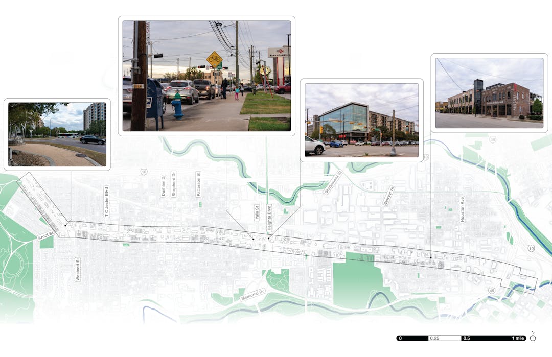
The Washington Avenue Corridor Study (WACS) guides short and long-range transportation reinvestments. It will encourage development of multimodal transportation options, increase safety, improve traffic flow, reduce congestion, and improve air quality. WACS will maintain the historic character of the corridor and foster a thriving, sustainable, and livable neighborhood.
A critical component of this study is safety analysis. The majority of the corridor is considered a component of the City of Houston’s “High Injury Network”. There are limited locations for safe pedestrian crossings along the corridor. The study will conclude with a prioritized list of recommended improvements and implementation strategy. Recommendations will offer equal emphasis on all modes of transportation and offer alternatives prior to final recommendations. Click here to learn more about the existing conditions on the corridor.
-
WACS Engagement Summary - Recommendations
Share WACS Engagement Summary - Recommendations on Facebook Share WACS Engagement Summary - Recommendations on Twitter Share WACS Engagement Summary - Recommendations on Linkedin Email WACS Engagement Summary - Recommendations linkOutreach Round 3: The public provided feedback on both the Community Preferred Vision and Baseline Constrained Alternative.
In the third round of outreach, the community was asked specific questions about various intersections throughout the corridor. These questions focused on bicycle infrastructure connections, station locations, and median placement. This public meeting was the last opportunity for in-person engagement in the study.
These comments were used to update the Community Preferred Vision and Baseline Constrained Alternative in this study.
Approximately 60 community members attended the in person open house.The materials shown at the open house are linked here.


-
WACS Existing Conditions Summary
Share WACS Existing Conditions Summary on Facebook Share WACS Existing Conditions Summary on Twitter Share WACS Existing Conditions Summary on Linkedin Email WACS Existing Conditions Summary linkFor full Existing Conditions report, click here.
There are many existing policies and previous studies that make recommendations for Washington Avenue.
 (Zoom in on your phone or browser) Throughout the last 20 years, many plans and studies have included Washington Avenue in their scope of work. Recommendations for the corridor range widely in scope and scale.
The right-of-way is limited along parts of Washington Avenue.
 (Zoom in on your phone or browser)
Washington Avenue corridor generally consists of 2 lanes with a middle turn lane in each direction. During off-peak hours, some portions of the outer lane turn into street parking in each direction. Although the number of lanes is fairly consistent throughout the corridor, the right-of-way (ROW) along Washington Avenue varies greatly, with the widest areas being up to 160 feet wide and the tightest segments being as narrow as 60 feet wide.
Crash data reveal several dangerous hotspots on Washington Avenue.
 (Zoom in on your phone or browser)
Over the past five years, more than 1,000 crashes have occurred along the study area corridor. More than 350 people have been injured in these crashes—including 19 seriously—and one person has been killed. Speeding, failure to maintain a lane, or changing a lane unsafely were top overall contributing factors.
There is no east-west bike connection through the neighborhood.
 (Zoom in on your phone or browser)Nearby Bayou Greenways give plentiful pedestrian and bicycle access to the edges of the Washington Avenue neighborhood, but once off the bayou paths, accessing destinations is difficult because there is a gap in the bicycle network in this area.
METRO Route 85 moves people far beyond Washington Avenue.
 (Zoom in on your phone or browser)
Houston METRO Route 85 moves people between the Greenspoint Transit Center and Downtown, using Washington Avenue for a large portion of its route. For people who live along Washington Avenue, the 85 is an essential connection to major transit hubs in both directions (Downtown, Northwest, and Greenspoint Transit Centers). The Route 85 is one of METRO’s frequent routes, with service every 15 minutes, and it is one of the highest ridership routes in Houston–based on October 2023 data, it is in the top 10 most ridden routes. Along Washington Avenue, the Route 85 stops frequently, sometimes twice within a block, and it intersects many other bus routes that people can transfer to and from.
Traffic patterns on Washington Avenue show that it is used more as a local connector than a commuter corridor.
 (Zoom in on your phone of browser for more details)
Like most roadways, the volume of vehicular traffic on Washington Avenue is generally highest during the morning and evening rush hours—with some exceptions where lunchtime traffic is higher than the morning peak. Beyond that, the corridor exhibits some unique travel patterns that reflect its role in the area transportation network. A detailed analysis shows that traffic operation is generally good along the Washington Avenue corridor, with most of the east-west through movements operating at Level of Service (LOS) C or better during the peak hours. Notably, a substantial portion of drivers use Washington Avenue as a connection from the surrounding neighborhood to the busy north-south arterials that cross the study area.
-
WACS Public Engagement Summary - What Works, What Doesn't?
Share WACS Public Engagement Summary - What Works, What Doesn't? on Facebook Share WACS Public Engagement Summary - What Works, What Doesn't? on Twitter Share WACS Public Engagement Summary - What Works, What Doesn't? on Linkedin Email WACS Public Engagement Summary - What Works, What Doesn't? linkWe heard from you! Thank you for your input in Phase 1. Many people gave their ideas in person and online through the map and activities on this website below.
- Interactive Map: What works about this corridor and what doesn’t?
- Ideas Pinboard: What alternatives could we consider?
Meeting 1 Presentation
Click here for a PDF with key highlights in English and Spanish!
Presentation at May 11 Public Meeting (includes Q&A):
Presentation recorded virtually:

What are the main issues facing the Washington Corridor today?
The corridor feels unsafe regardless of how people travel.
Providing a safe corridor for everyone was the most important issue. People rolling, moving on foot, biking, riding transit, and driving are unsatisfied with the safety of the corridor, citing unsafe crossings, intersections, sidewalks, and road design as their main concerns for the corridor.
Important connections to ped/bike trails, transit, and major destinations are missing.
Two Bayou trails run parallel to Washington, but don’t connect to the corridor, even where connections would be easy to make. Transfers between bus routes are unclear and lead to missed connections, and major destinations are hard to get to by car due to turning conflicts, at grade railroad crossings, and lack of signalization.
Most buildings lack a strong relationship to the street and places to sit and eat outside.
The lack of interest and the space between sidewalks and buildings makes the corridor less interesting and more exposed to walk along and doesn’t encourage people to interact with each other or shop.

What people imagine for the future of the corridor:
People want to see a thriving, sustainable, livable Washington Corridor.

When asked what people want the corridor to feel like in 2045, they overwhelmingly described a lively, active corridor that feels like a main street or european city, with buildings built closer to the street and wide shaded sidewalks filled with people, places to sit and eat or drink coffee. They also included safety improvements and public transportation.

People want to feel safe.
People moving along and across the Washington Avenue Corridor do not feel comfortable regardless of mode. Most people want to see bike lanes, wider sidewalks, improved crossings, and narrower car lanes. Pedestrians, cyclists, and transit users say comfort is very important, and if every mode of transportation felt equally comfortable, 75% of their driving trips may switch to a different mode. Over 90% of walking trips might switch to biking or taking transit, and almost 80% of bike trips would switch to walking.
People want transportation options.
Many people’s visions for the corridor involve an east-west light rail line or dedicated bus lanes, bike lanes that connect to other bike facilities, bike parking, and reduced car lanes. In the spatial trade-offs activity every participant reduced driving lanes to have better pedestrian, bike, and transit facilities.
People imagine pleasant outdoor common areas.
Shade, buffering from car lanes, seating and outdoor dining become a desired image for the overall avenue. People want to be able to walk the avenue in pleasant public spaces.

Thank you for your comments! In our next round of outreach we will present design alternatives for the Washington Corridor.


Final Documents
-
 Washington Avenue Corridor Study Executive Summary (26.1 MB) (pdf)
-
Washington Avenue Corridor Study - Introduction Chapter (32.9 MB) (pdf)
-
Washington Avenue Corridor Study - Existing Conditions and Goals Chapter (146 MB) (pdf)
-
Washington Avenue Corridor Study - Alternatives Chapter (29.9 MB) (pdf)
-
Washington Avenue Corridor Study - Recommendations Chapter (156 MB) (pdf)
-
Washington Avenue Corridor Study - Appendices (60.3 MB) (pdf)